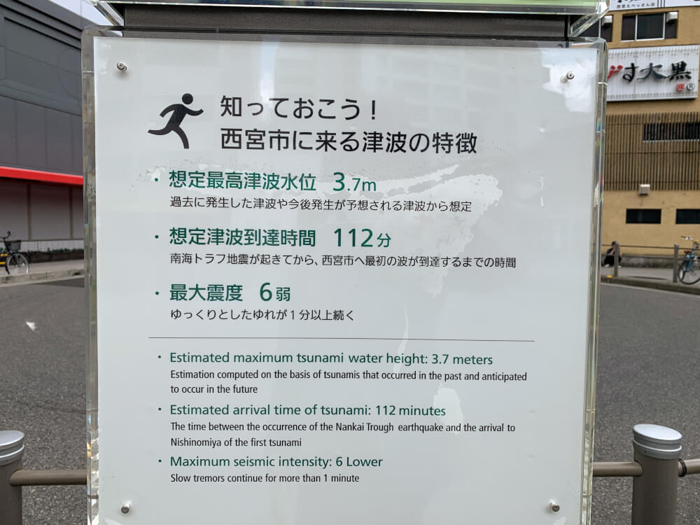
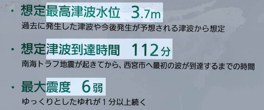
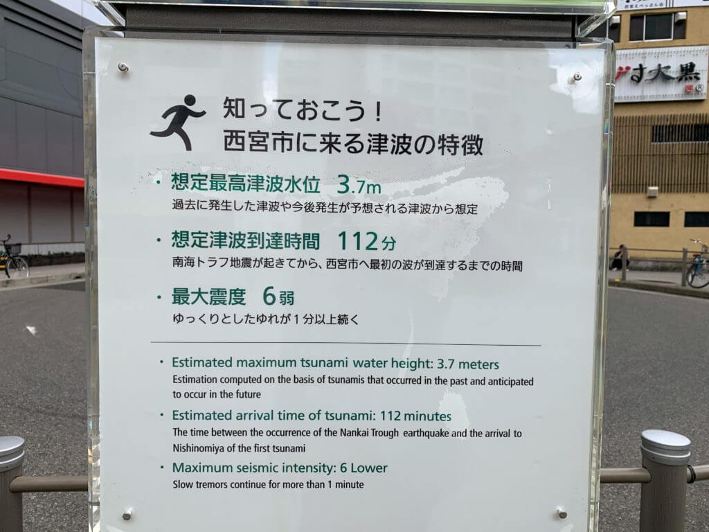
It looks like if a Nankai Trough earthquake occurs, it would take 112 minutes for the first tsunami to reach Nishinomiya City.
In this article, we’ve summarized the areas where evacuation is required, evacuation methods, and about how long it would take to evacuate on foot from Nishinomiya’s three coastal areas.
Please use this as a reference.
First, take a look here↓
This is based on the assumed Nankai Trough earthquake scenario.
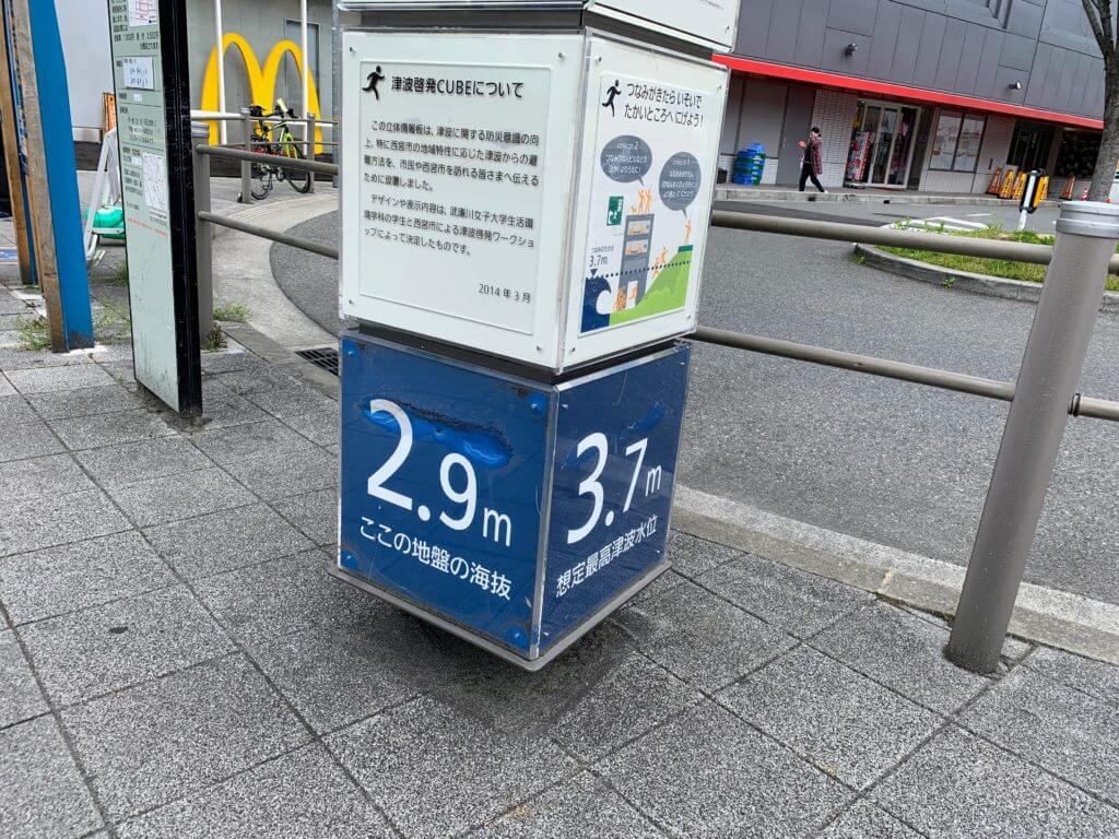
The maximum tsunami water level is expected to be 3.7m, and it seems the first tsunami would arrive just under 2 hours, or 112 minutes, after the earthquake occurs.
That may sound like there is plenty of time, but evacuation can take longer than you might expect.
Better safe than sorry
A sudden major earthquake can make it hard to stay calm.
Earthquake occurs
↓
Panic
↓
You realize an earthquake has happened
↓
Prepare to evacuate
↓
Finally start evacuating
The time it takes to start evacuating will vary from person to person.
Earthquakes can cause injuries and other problems. It’s best to be prepared so you can act whenever one happens.
For example, preparations like these:
- “Keep tomorrow’s clothes by your pillow”
- “Keep your wallet, smartphone, charger, and cable by your pillow too”
- “Place your emergency evacuation bag somewhere easy to grab”
It also seems like a good idea to talk with your whole family in advance about what to do if everyone is affected by the disaster in different places.
目次
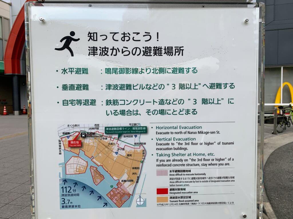
Southern Nishinomiya City is highly likely to flood
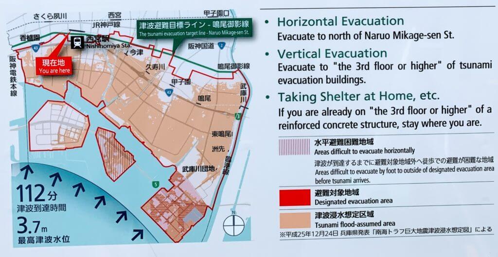
The area inside the red outline on this map is the area that needs to evacuate.
Basically, it seems that people living south of the Naruo-Mikage Line should evacuate.
The colored areas can generally be considered to be at an elevation of between 3m and less than 4m.
Koshien Station, Nishinomiya-hama, parts of Takasu, and Imazuhama Park may be at elevations of 4m or higher, but they are still designated evacuation areas.
For tsunami evacuation, it seems you should head north of the Naruo-Mikage Line.
There appear to be three evacuation methods
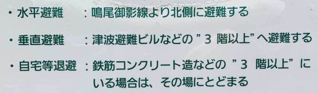
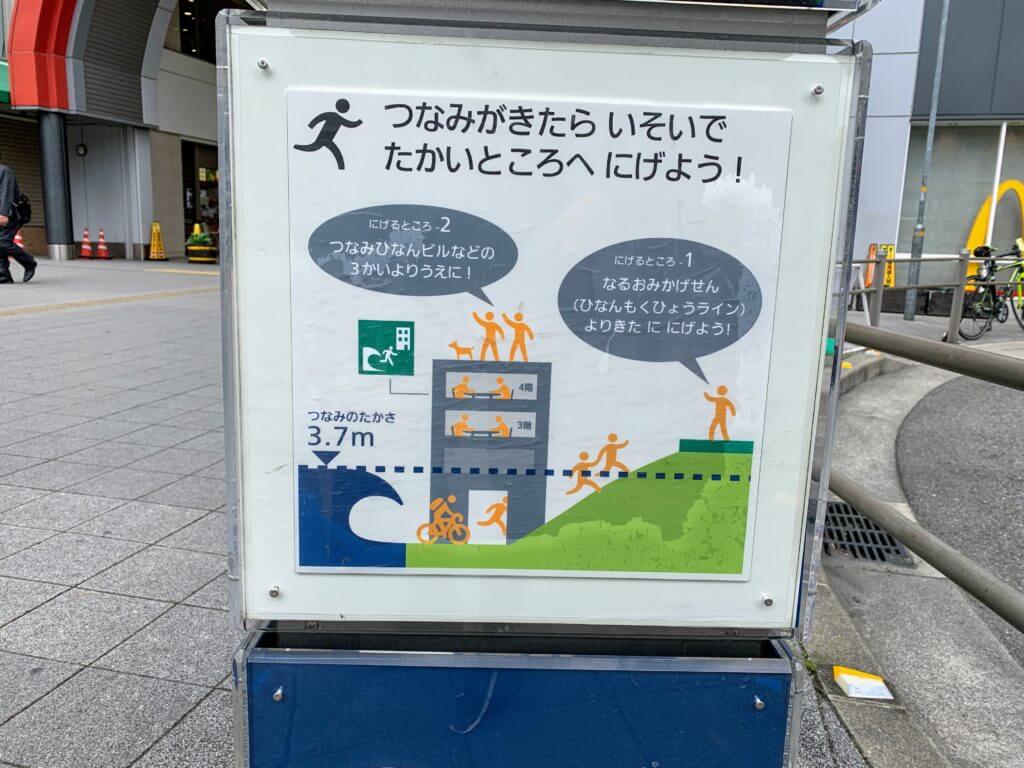
- Horizontal evacuation: Evacuate toward the north side where the tsunami will not reach
- Vertical evacuation: Evacuate to the 3rd floor or higher of a tsunami evacuation building, etc.
- Shelter at home, etc.: If you are on the 3rd floor or higher of a reinforced concrete building, stay where you are
To check whether there is a tsunami evacuation building nearby, it seems you can use the evacuation building and shelter search.
Please also refer to Nishinomiya City’s general information page on tsunami evacuation buildings.
How long it takes to escape on foot
We checked Google Maps route searches to see how many minutes it would take to walk to the Naruo-Mikage Line from three locations in southern Nishinomiya: Nishinomiya-hama, Koshien-hama, and Naruo-hama.
It is safest to assume that young children and elderly people may take 2 to 4 times longer than the times listed here.
Evacuating from Naruo-hama Seaside Park
This assumes evacuating on foot from Naruo-hama Seaside Park.
The time was 1 hour and 1 minute. The walking distance was 4.7km.
Evacuation from near Takasu Elementary School takes 41 minutes on foot.
Evacuating from Koshien-hama Seaside Park
This assumes evacuating on foot from Koshien-hama Seaside Park.
It takes 44 minutes on foot. The walking distance was 3.7km.
Areas near Koshien-hama
- Evacuation from near Masago Junior High School takes 20 minutes on foot.
- Evacuation from near Hama-Koshien Sports Park takes 34 minutes on foot.
Evacuating from Nishinomiya-hama
This assumes evacuating on foot from the southwestern edge of Nishinomiya-hama.
It takes 44 minutes on foot. The walking distance was 3.5km.
Areas near Nishinomiya-hama
- Evacuation from near Hamaebisu Park takes 18 minutes on foot.
- Evacuation from near Nishinomiya Kaisei Hospital takes 16 minutes on foot.
There is evacuation guidance at the Ebisu Exit of Hanshin Nishinomiya Station
There was tsunami evacuation guidance on the south side of the Ebisu Exit at Hanshin Nishinomiya Station.
Let’s prepare in advance.