Just after 11 p.m. on December 8, a magnitude 7.6 earthquake occurred with its epicenter off the eastern coast of Aomori Prefecture, and tsunami warnings (up to 3 m) have been issued for the central Pacific coast of Hokkaido, the Pacific coast of Aomori Prefecture, and Iwate Prefecture. It’s quite far from Nishinomiya, but many of you may have felt startled when you saw the news reports.
Meanwhile, as of now, no tsunami warnings or advisories have been issued for Nishinomiya City or the coastal areas of Hyogo Prefecture. Still, when news like this comes out, it naturally makes you wonder again, “What would happen to Nishinomiya if a Nankai Trough earthquake occurred?”
So we’re revisiting and slightly updating a previous Nishitsu article titled “If a Nankai Trough earthquake occurs, a tsunami would reach Nishinomiya 112 minutes later”, and summarizing the key points here.
目次
- 1 If a Nankai Trough earthquake occurs, Nishinomiya’s tsunami is expected to arrive “about 112 minutes later”
- 2 These are the areas in southern Nishinomiya where evacuation is needed
- 3 There are 3 ways to evacuate from a tsunami
- 4 How long does it take to “escape on foot” from Nishinomiya’s three waterfront areas?
- 5 Take at least one look at the tsunami hazard map too
- 6 Also check the tsunami guidance at Hanshin Nishinomiya Station
- 7 Finally
If a Nankai Trough earthquake occurs, Nishinomiya’s tsunami is expected to arrive “about 112 minutes later”
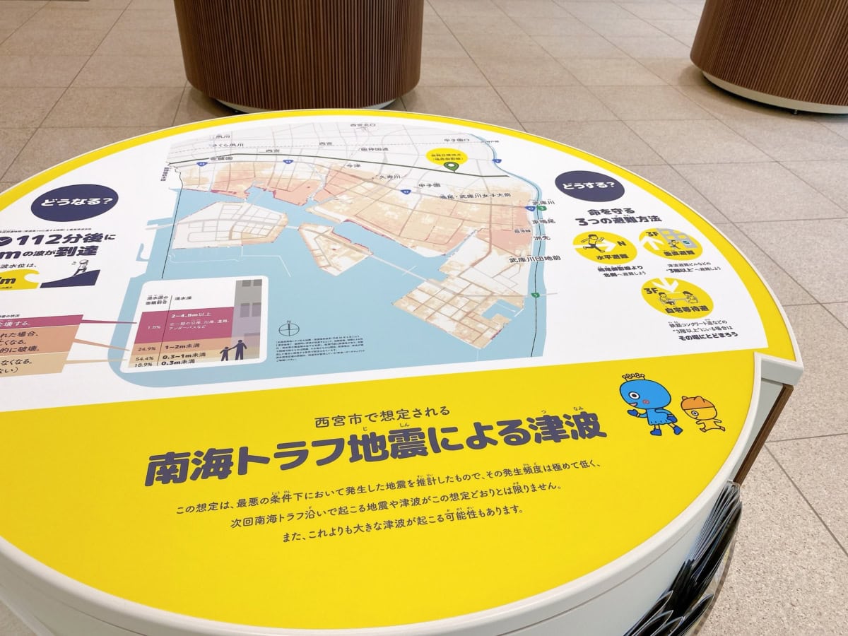
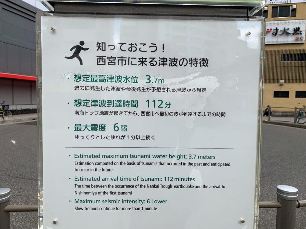
First, take a look at this diagram↓
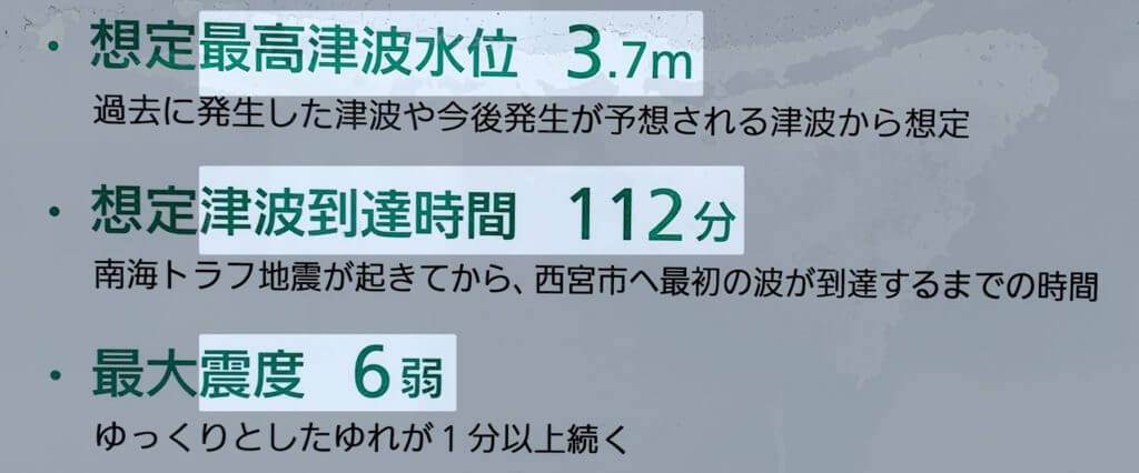
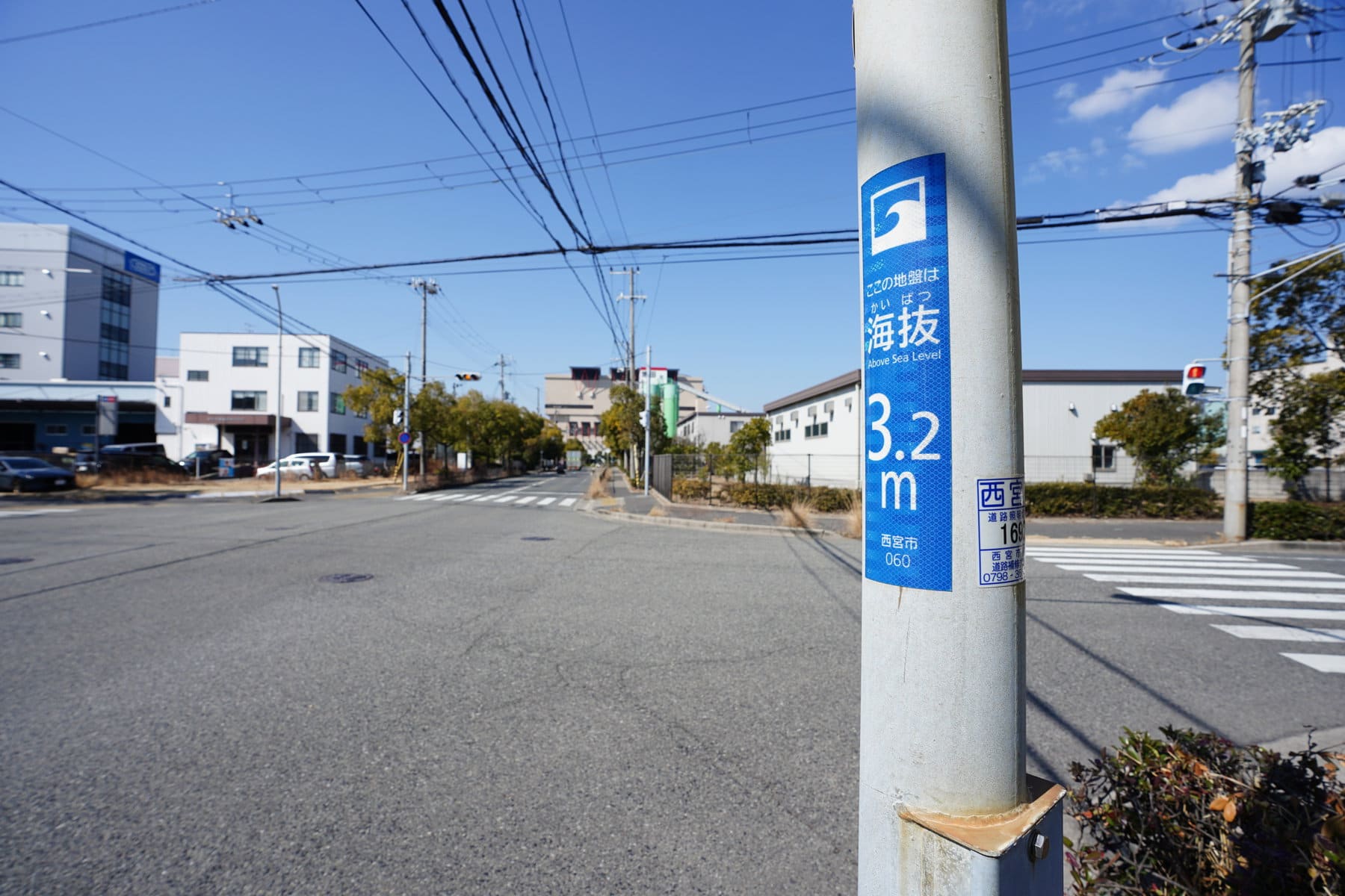
This is the Nankai Trough earthquake tsunami projection published by Nishinomiya City.
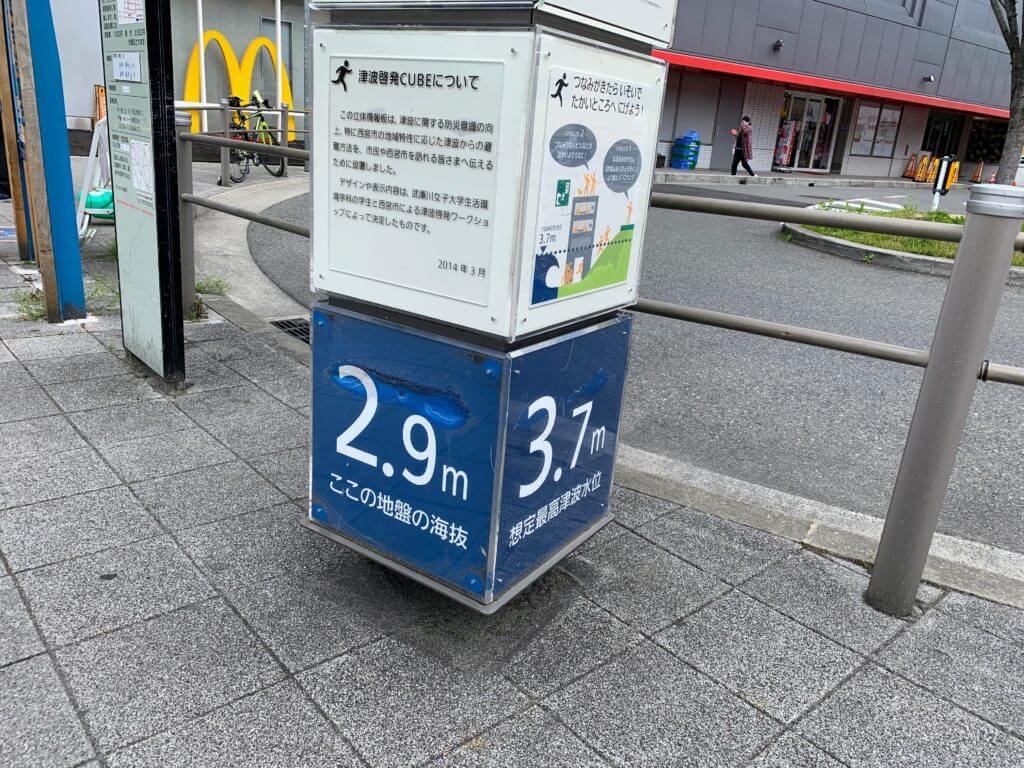
- Assumed maximum tsunami height: 3.7 m
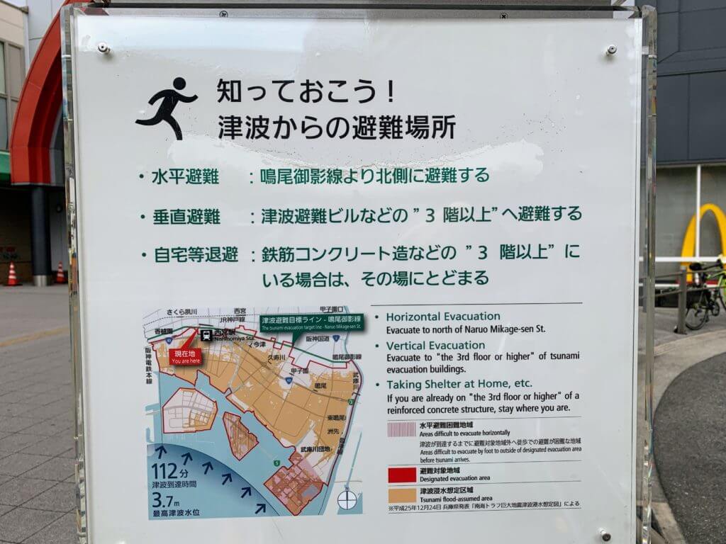
- Time from earthquake occurrence to first tsunami arrival: About 112 minutes (just under 2 hours)
Looking only at the numbers, you might think, “That’s actually quite a bit of time,” but it can take surprisingly long before people actually start evacuating.
Decide your “preparedness steps” before panic sets in
When a sudden major tremor hits, people often end up reacting like this.
↓
Panic
↓
Try to understand the situation
↓
Think about family and belongings
↓
Finally start evacuating
How many minutes it takes to reach that “finally start evacuating” point varies from person to person. If you get injured or your home is thrown into chaos, it can take even longer.
That’s why “deciding things in advance” seems so important.
- “Keep tomorrow’s clothes by your pillow”
- “Keep your wallet, smartphone, charger, and cable together by your pillow”
- “Keep your emergency bag near the entrance or another exit where you can grab it quickly”
It’s also important to talk in advance about what to do if family members are affected while in different places. You’ll want to decide, even roughly, on things like a meeting place and how to contact each other.
These are the areas in southern Nishinomiya where evacuation is needed
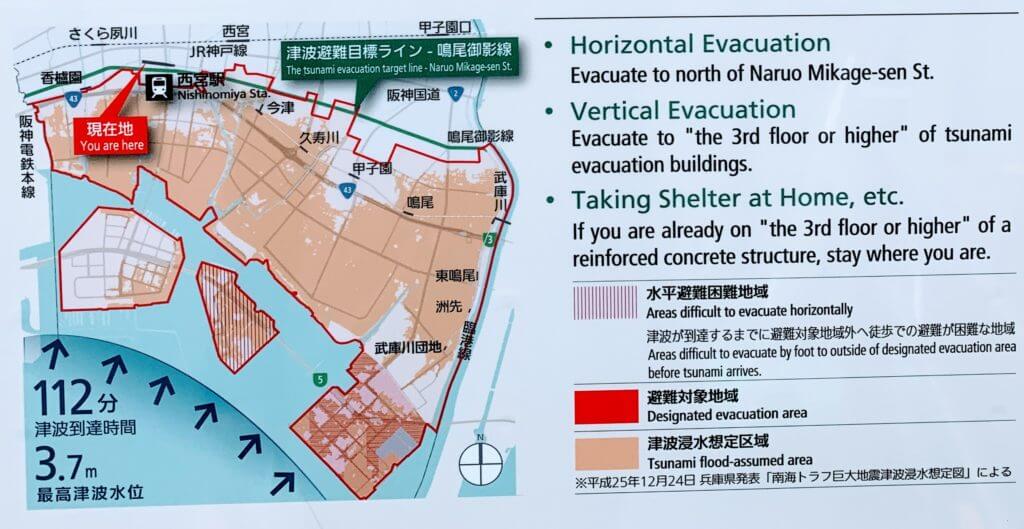
The area inside the red frame on this map is considered an area where evacuation is generally required in the event of a tsunami.
Roughly speaking:
- Areas south of the Naruo-Mikage Line are basically evacuation target areas
- Areas shown in color can be understood as being under 3 to 4 m above sea level
- Koshien Station, Nishinomiya-hama, parts of Takasu, Imazuhama Park, and some other areas seem to be 4 m or higher, but they are still included in tsunami evacuation target areas
When escaping from a tsunami, it’s easy to remember that you should aim north of the Naruo-Mikage Line no matter what.
There are 3 ways to evacuate from a tsunami
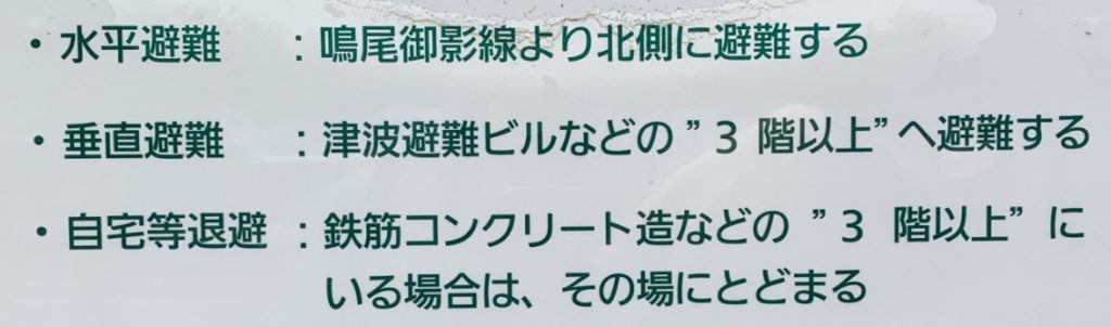
According to Nishinomiya City’s projections, there are three main ways to evacuate from a tsunami.
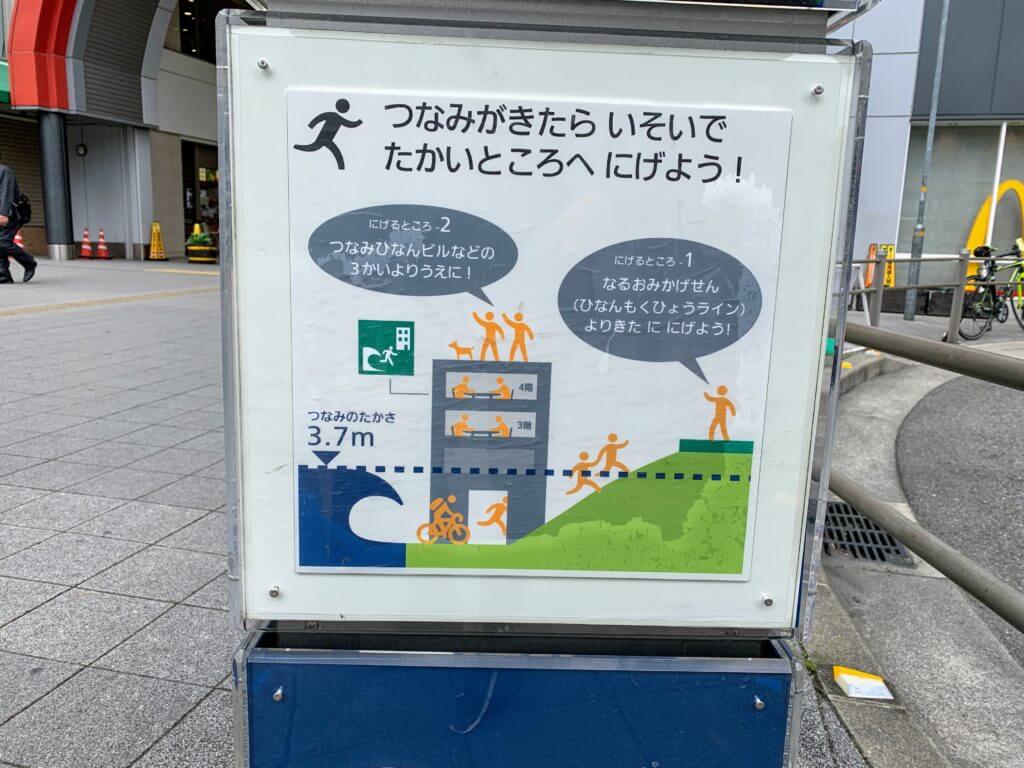
- Horizontal evacuation: Evacuate on foot to the north side where the tsunami will not reach (north of the Naruo-Mikage Line)
- Vertical evacuation: Escape to the 3rd floor or higher of a reinforced concrete building, such as a tsunami evacuation building
- Sheltering at home or similar location: If you are already on the 3rd floor or higher of a reinforced concrete building, stay where you are
You can check whether there is a tsunami evacuation building nearby using the Evacuation Building / Shelter Search.
It also seems worth opening Nishinomiya City’s general information page on tsunami evacuation buildings at least once.
How long does it take to “escape on foot” from Nishinomiya’s three waterfront areas?
From here, we’ll review about how many minutes it takes to walk from Nishinomiya-hama, Koshien-hama, and Naruo-hama to the Naruo-Mikage Line. These estimates were checked on Google Maps as a guideline for an adult walking at a normal pace.
For small children and elderly people, it’s safer to assume it may take about 2 to 4 times longer than the times written here.
If evacuating from Naruo-hama Rinkai Park
This assumes evacuating on foot from Naruo-hama Rinkai Park to the area near the Naruo-Mikage Line.
The time is about 1 hour and 1 minute, and the distance is about 4.7 km.
Evacuation from around Takasu Elementary School takes about 41 minutes on foot.
If evacuating from Koshien-hama Seaside Park
This assumes evacuating from Koshien-hama Seaside Park to the Naruo-Mikage Line.
It takes about 44 minutes on foot, and the distance is about 3.7 km.
Examples near Koshien-hama
- Evacuation from around Masago Junior High School takes about 20 minutes on foot
- Evacuation from around Hama-Koshien Sports Park takes about 34 minutes on foot
If evacuating from Nishinomiya-hama
This assumes evacuating from around the southwestern end of Nishinomiya-hama to the Naruo-Mikage Line.
It takes about 44 minutes on foot, and the distance is about 3.5 km.
Examples near Nishinomiya-hama
- Evacuation from around Hamaebisu Park takes about 18 minutes on foot
- Evacuation from around Nishinomiya Kaisei Hospital takes about 16 minutes on foot
Take at least one look at the tsunami hazard map too
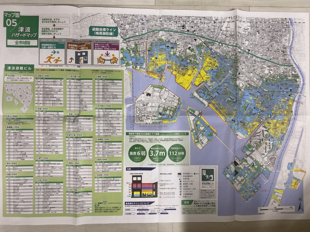
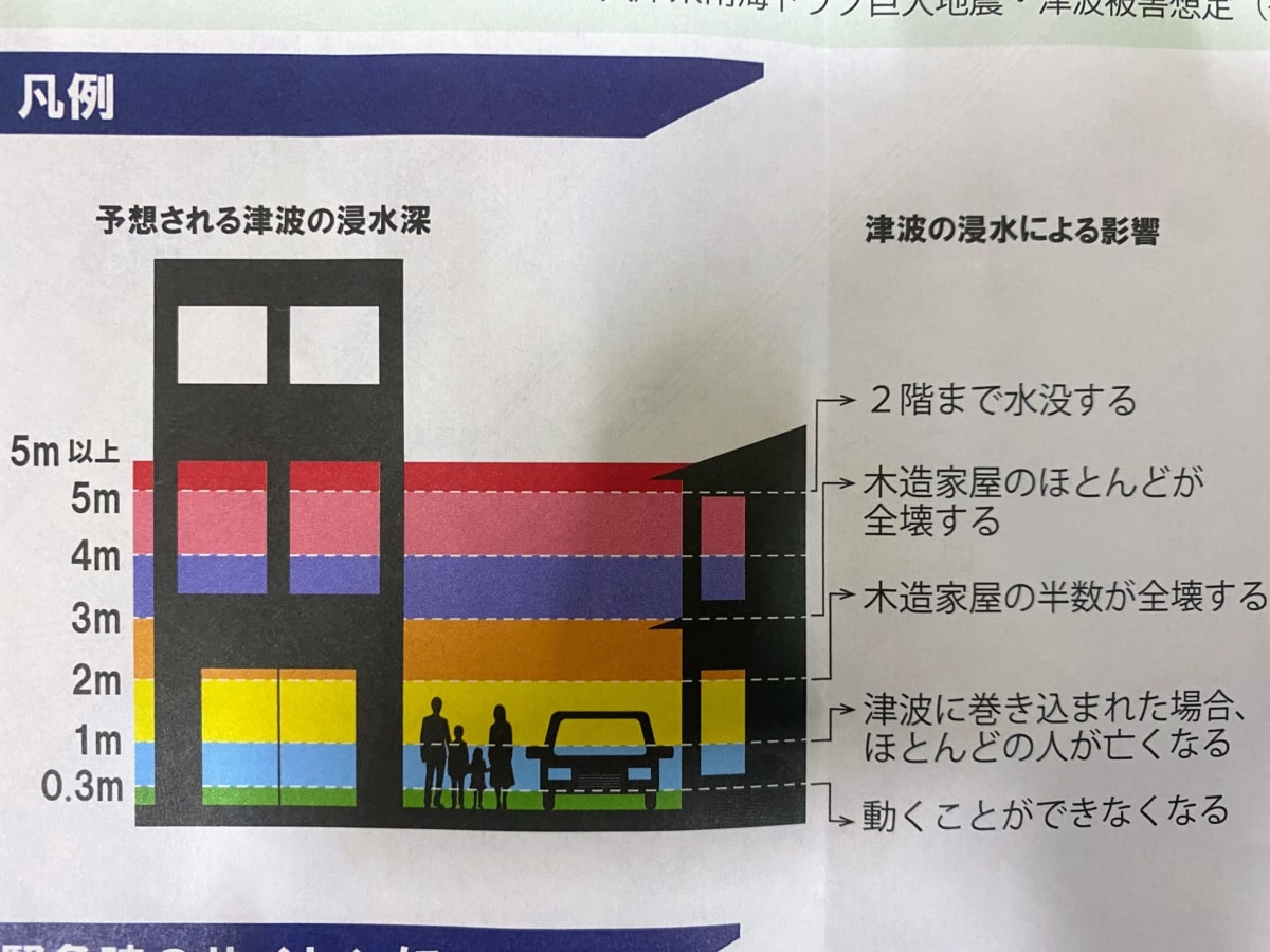
In Nishinomiya, there are blue, yellow, and orange areas.Be especially careful in colored areas.
Also check the tsunami guidance at Hanshin Nishinomiya Station
On the south side of the Ebisu Exit at Hanshin Nishinomiya Station, there is also a tsunami evacuation guidance sign.
When you pass nearby, even just once, try mentally rehearsing “which way would I escape from here?” It could make a big difference in how easily you can move when it really matters.
Finally
On a day like today, when news of a major earthquake or tsunami in a distant region comes in, many people probably feel worried and think, “What should I do if the Nankai Trough earthquake happens…?”